Start Growing Your Business
with map based Hub4Everybody
Easy publishing, sharing and cooperative management of geographical datasets
GET STARTED

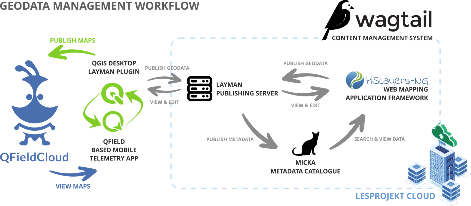
Map based platform
Build web portal on top of your geo-data

Web and desktop client - QGIS
Manage your data no matter if using web browser or QGIS Desktop. View even on mobile.

Publishing, sharing and cooperative management
Simple publishing and map creation for anyone
Maximize the use of map-based data
THE EASIEST WAY
Hub4Everybody is a one-of-a-kind solution for publishing, sharing and cooperative management of geographical datasets, such as professional data and measuring, results of research projects or student papers, educational materials, emotional maps, visualization of in-field research and other maps, tables, or databases.
You can easily upload or update your data as well as adjust the parameters of sharing among different audiences. Hub4Everybody is an alternative tool combining online office software with an editorial system for spatial data. It is also an Open-Source alternative to already existing commercial solutions, while offering additional extending options.
CONTACT USDo you have various digital maps piling up on your pc?
It could be scored student papers, emotional maps, results of in-field research or scientific experiments. Would you like to publish your results and activities, promote, or discuss them among different target audiences? All these requirements can be handled by a system for publishing and sharing of geographical data. We can offer a unique, scalable solution, which is suitable for all kinds of organizations.
of development
We are a strong technology partner
We use Lesprojekt could
We are delivering the results of our development – a unique and adaptable solution based on open sources, which can easily be used in any kind of organizations (from national institutions, over different type of schools and universities, up to SME´s or public authorities), that needs to manage and publish geographical data.
WHO CAN USE HUB4EVERYBODY?
Hub4Everybody can be used by whoever wants to publish and present their data while there is no need to invest into professional GIS or into developers programming and updating their own solutions. Hub4Everybody is designed for SME´s, high schools and universities, research organizations as well as public authorities, NGO´s and many others.
WHY SHOULD YOU USE HUB4EVERYBODY?
Hub4Everybody offers all usual functions of geoportals (working with a map, linking of external data and services) but on top of that it offers a possibility to link desktop and mobile solutions for geographical data processing, data visualisation in form of storyboard and communication components via social networks. The solution is scalable and fully adaptable to the end-user needs. You can store your data directly on Hub4Everybody cloud or in your own infrastructure. All technologies used for Hub4Everybody are open source, which enables you to communicate with all kinds of users all over the world while no costs are necessary.
WHERE CAN YOU TEST HUB4EVERYBODY?
Hub4Everybody can be tested here: testing web pages, but it is also possible (and recommended) to test it within the international 2022 AgriHub Hackathon. Challe nge Nr. 9 - A new social space for geographic information sharing and education is dealing with testing and publishing of geographical data through Hub4Everybody. A series of webinars will be organized to present different components of solutions.
Pricing Plans
Free Plan
You can test all functionality and tools on this portal
Testing instalation
Support via contact form
Non commercial use
No monitoring and reports
SIGN UPH4E Cloud
Dedicated instance on our Cloud infrastructure
Stable infrastructure
Support 24/7
New updates
Monitoring and reports
CONTACT USCustomer infrastructure
Installation on customer's own infrastructure
Customer infrastructure
Paid updates
Paid monitoring
Paid support
CONTACT USRecent Blog Posts

Map Whiteboard Introduction
Presentation in PDF for download [3,1MB]: Map Whiteboard Introduction EN | Map Whiteboard Introducción ES
Read more
Hub4Everybody - introduction
Presentation in PDF for download [2,9MB]: Hub4Everybody Introduction EN | Hub4Everybody Introducción ES
Read more
Local attractiveness
The attractiveness of territorial units (territorial attractiveness) is described as the diversity and complexity of many interrelated factors such as economic attributes (e.g. foreign investment), c
Read more