Normalized Difference Water Index (NDWI)
What is Normalized Difference Water Index (NDWI) ?
The Normalized Difference Water Index (NDWI) can refer to two indices derived from remote sensing and related to liquid water.
The first, proposed by Bo-Cai Gao in 1996, is used to monitor changes in leaf water content, using near-infrared (NIR) and short-wave infrared (SWIR) wavelengths. The combination of the NIR with the SWIR makes it sensitive to changes in liquid water content and in spongy mesophyll of vegetation canopies (Gao, 1996 ; Ceccato et al., 2001). This index is useful for studying vegetation in areas affected by drought. It has many applications (agricultural monitoring, crop irrigation, pasture management, fire risk assessment) and is of particular interest in the context of climate change.
The second, proposed by Stuart K. McFeeters in 1996, is used for the water bodies analysis. The index uses Green and Near infra-red bands of remote sensing images that allows it to detect subtle changes in water content of the water bodies. Higher NDWI values indicate sufficient moisture, while a low value indicates water stress. This can be useful when looking for water bodies or a change in water level (e.g. flooding).
How do you calculate NDWI?
NDWI (Gao, 1996) = (NIR - SWIR)/ (NIR + SWIR)
For Sentinel-2 satellite, two formulations are possible:
- NDWI (sentinel 2) = (B8a – B11) / (B8a + B11)
- NDWI (sentinel 2) = (B8a – B12) / (B8a + B12)
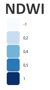
Index values between -1 and 0 correspond to bright surface with no vegetation or water content. Higher index values correspond to water content.
NDWI (K.McFeeters, 1996) = (Green – NIR) / (Green + NIR)
NDWI (sentinel 2) = (B3 - B8a) / (B3 + B8a)
Index values greater than 0.5 usually correspond to water bodies. Vegetation usually corresponds to much smaller values, and built-up areas to values between zero and 0.2.
References:
https://edo.jrc.ec.europa.eu/documents/factsheets/factsheet_ndwi.pdf
https://custom-scripts.sentinel-hub.com/custom-scripts/sentinel-2/ndwi/
Example of NDWI (Gao), Rostenice farm